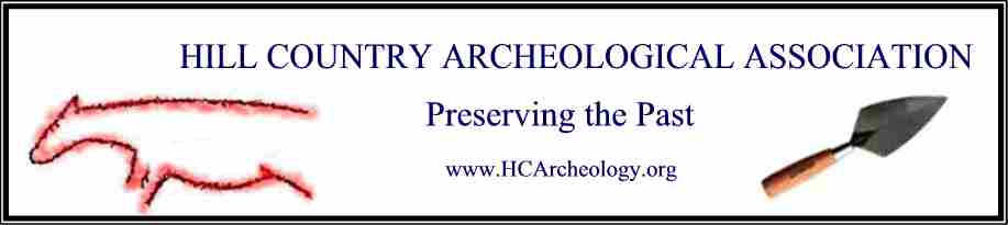
General Meeting Details
-
 HCAA General Meeting August 8 2026
June 6, 2026
HCAA General Meeting August 8 2026
June 6, 2026
Transcript:
Of all the prehistoric civilizations, the peoples of southwest Texas left behind more traces of their past than most.
Northwest of Del Rio, where the Pecos River meets the Rio Grande, there are dozens of caves and rock shelters decorated with complex artwork – depictions of animals, strange humanoid figures, landscapes, and indecipherable religious symbols.
The paintings share obvious similarities, but they weren’t all produced at the same time. In fact, a new study shows that they were created over a span of 4,000 years. The paper gives new insight into the process of making these murals, and what they might have meant.
Carolyn Boyd co-authored the study. Boyd is the Shumla Endowed Research Professor in Anthropology at Texas State University. She spoke to the Texas Standard about her research. Listen to the interview above or read the transcript below.
This transcript has been edited lightly for clarity:
Texas Standard: So why is it so important to assign a date to these rock artworks in South Texas?
Carolyn Boyd: It’s so important for us to know when these were produced, really, for so many reasons.
One, we have abundant deposits that are really well preserved in the caves and rock shelters out in the lower Pecos. But prior to now, we had no way to tie what’s in the dirt to what’s on the walls. And now we can, because we can date the deposits.
We can also date the wall, date the paintings and know the relationship between the two. And really what this is doing is connecting the material aspects with the immaterial aspects of the human past – the belief systems, the cosmologies, the cognitive systems of the people that produced these arts, as well as left all of the deposits that we’re able to excavate today.
Can you tell us about the techniques you made to make these connections and date this art?
Well, there’s a lot that went into this. And the person that really has refined the technique for radiocarbon dating the paintings, which is what we did, was Dr. Karen Steelman. She’s one of the co-authors, and she is the science director at Shumla.
What Karen did was to use a system called plasma oxidation to extract organic material from the paint itself. Paint is going to be made up of, we know, mineral pigments. That’s what gave the paint color. But it also has to have a binder. And the binder, we suspect, was some kind of an animal fat, and perhaps also an emulsifier, which would be something like yucca.
Well, those ingredients all contain organic matter. And this system called plasma oxidation extracts from the paint sample those organic materials. And then we’re able to send that organic carbon off to a radiocarbon lab to obtain a date.
But what we did, we took it a little step further. There’s layers and layers of paint. And we wanted to know specifically when and where in those layers of paint this paint sample came from.
So we used digital microscopes to go in and study the painting sequence so that we can understand how the artists originally applied the paint, the order that the paint was applied to the wall, and then select a specific location from the bottommost layer, the middle, and the top to obtain the date.
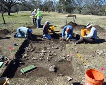
Carolyn Boyd / Courtesy photo
Teams from Texas State University and Shumla Archaeological Research & Education Center work together to analyze the Panther Cave mural at Seminole Canyon State Park and Historic Site.
So throughout this 4,000 years of consistent artwork in the region… I mentioned the humanoid figure, the animals, these religious symbols… What elements remained consistent and what were some of the major changes you found?
You know, I think this is one of the things that, to me, was the most striking.
This Pecos River-style painting, which is what we’re studying here, these murals were in production for 4,000 years. And when I say they were in production for 4,000 years, I’m not meaning that each mural is a collection of images that accrued over 4,000 years. What we found was that each mural that we dated, the dates within those murals were statistically indistinguishable, which indicated that they were painted in a relatively short period of time.
We dated 12 sites, and they spanned that full 4,000 years. That is stunning. That’s just simply stunning, because it tells one, that these murals are like compositions or narratives. And the information, the way that they painted them was passed down across 175 generations. They’ve used the same graphic vocabulary, same symbol system, and they even used the means of painting it.
We found that they followed a very strict rule when they applied the paint. They applied all the black paint first, then they allowed that to dry, then they applied red, then the yellow, and then the white. And that rule endured also across that 4,000 years.
But we also found that there were specific symbols that endured across the whole 4,00 years. There’s a motif that we refer to as the “power bundle,” which is this odd-looking thing that looks like a seed pod at the end of a stem. And it’s held in the hand of the human-like or anthropomorphic figures.
And it’s an unusual symbol. It’s one that you don’t find anywhere else, except in the lower Pecos. And it was produced at 6,000 years ago, and it appeared throughout the full 4,000 years.
» GET MORE NEWS FROM AROUND THE STATE: Sign up for Texas Standard’s weekly newsletters
Well, what do you think these depictions say about how these people understood the universe?
One thing I guess I would really like to stress is that these images, we think of them as just paintings on a wall. That would not have been the way that the original creators would have looked at them or the Indigenous folks today look at them.
Instead, that these were living – that each one of these images is a living, breathing entity that is engaged in, today, the maintenance and the creation of the cosmos. So it’s a living art. So it’s a world that’s very much alive, where everything is alive.
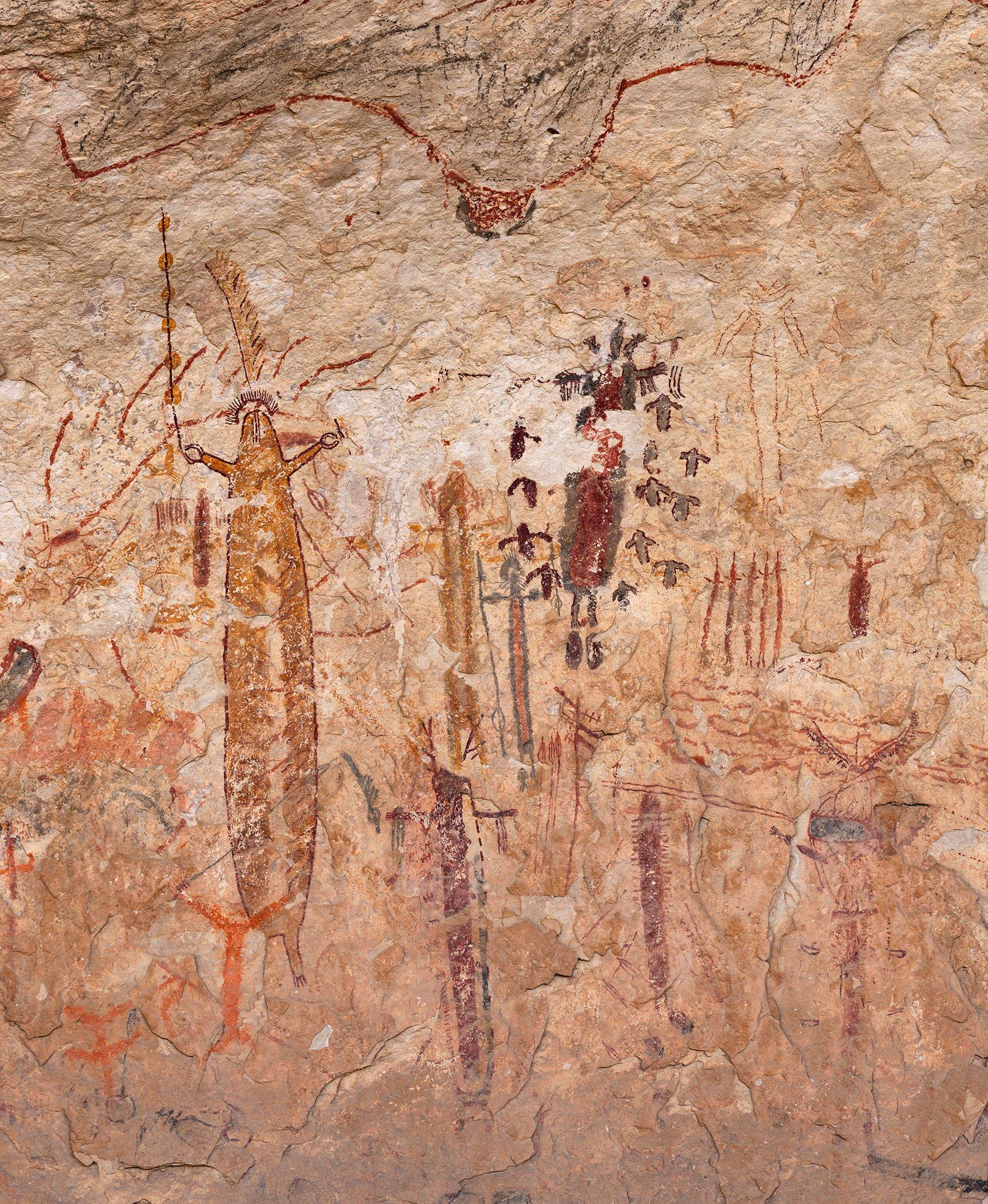
The 2,000-year-old mural at Halo Shelter is among the younger dated Pecos River-style paintings but contains the same iconographic elements found throughout production of the style. Shown here is a six-foot section of the 100-foot-long Halo Shelter mural. Carolyn Boyd / Courtesy photo
Another thing ties back to, again, this fascinating painting sequence where they’re following this succession or movement from the darker hues to the lighter hues.
When I interacted with and talked with some Indigenous consultants in Mexico, what they told me when I asked them the question of “why do you think that the people of the Pecos thousands of years ago would have followed this rule?” They looked at me like, “you poor thing, that’s an unusual question for you to ask.”
Because, to them, it seemed very natural. They said, well, black would have been painted first because black is associated with primordial time – with the dark waters of the underworld. This is the nighttime, if you will, the time before the sun has been born.
Red is associated with that time of the day just before the sun rises where you get that beautiful red glow on the horizon – that’s the fires in the underworld. That’s the sun just before it comes up on the horizon.
Yellow, then, is the next color that would be applied because that is the rays of the sun. That’s sunlight, the warmth of the sun on the Earth. And then the cycle continues. You go back into the night and you just keep going.
So they’re literally painting time and creation into the murals as they’re painting it. And it just tells us a great deal about how they were viewing their landscape, how they we’re interacting with the world around them.